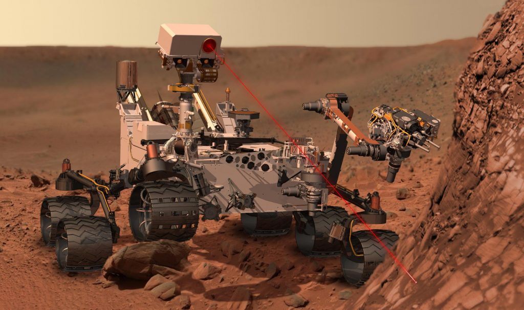
ChemCam
I am a member of the science team for the ChemCam instrument on the Curiosity Mars rover. ChemCam is a camera combined with a laser-induced breakdown spectroscopy (LIBS) instrument, which is a fancy way of saying that we zap rocks to figure out what they are made of. A lot of my work involves developing software to make it easier to analyze data from the instrument and to improve the accuracy of the chemistry that we infer from the spectra. I was also involved in a campaign to use long-distance ChemCam remote micro-imager (RMI) images to study the slopes of Mt. Sharp.
Selected Publications
- Anderson, R. B., et al. (2017). Improved accuracy in quantitative laser-induced breakdown spectroscopy using sub-models. Spectrochimica Acta Part B: Atomic Spectroscopy, 129, 49-57. https://doi.org/10.1016/j.sab.2016.12.002
- Clegg, S. M., Wiens, R. C., Anderson, R.B.,et al. (2017). Recalibration of the Mars Science Laboratory ChemCam instrument with an expanded geochemical database. Spectrochimica Acta Part B: Atomic Spectroscopy, 129, 64-85. https://doi.org/10.1016/j.sab.2016.12.003
- Anderson, R.B., et al. (2015). ChemCam results from the Shaler outcrop in Gale crater, Mars. Icarus, 249, 2-21. https://doi.org/10.1016/j.icarus.2014.07.025
- Wiens, R. C., Maurice, S., Lasue, J., Forni, O., Anderson, R. B., et al. (2013). Pre-flight calibration and initial data processing for the ChemCam laser-induced breakdown spectroscopy instrument on the Mars Science Laboratory rover. Spectrochimica Acta Part B: Atomic Spectroscopy, 82, 1-27. https://doi.org/10.1016/j.sab.2013.02.003
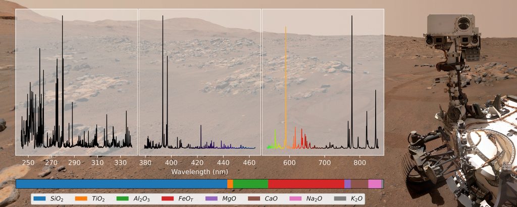
SuperCam

I am also a member of the science team for SuperCam, the next generation of ChemCam, which will fly on the Mars 2020 rover. SuperCam does everything ChemCam can do, but it also can collect Raman spectra (to identify minerals and organics), and near-infrared reflectance spectra (to identify minerals, especially those containing water). Its images are in color, and SuperCam also has a built-in microphone to record sounds from the surface (wind, rover sounds, and the sound of the laser zapping targets).
I play a leading role on the team developing the multivariate regression models used to estimate target chemistry based on the observed spectra. Our initial calibration was published in 2022, and we are currently (as of mid-2023) working on an improved calibration using a larger suite of laboratory spectra and a more sophisticated approach to optimizing the data processing and model parameters.
Selected SuperCam Publications
- Anderson, R. B., et al. (2022). Post-landing major element quantification using SuperCam laser induced breakdown spectroscopy. Spectrochimica Acta Part B: Atomic Spectroscopy, 188, 106347. https://doi.org/10.1016/j.sab.2021.106347
Spectral Analysis Tool (PDART)
I am currently leading a project to develop a free, open-source spectral analysis tool designed specifically for analyzing LIBS spectra from instruments like ChemCam and SuperCam. The goal is to provide the scientific community with something easy to use via graphical interface, but powerful and flexible. Among other capabilities, the tool will be capable of preprocessing steps such as masking, continuum removal, and normalization; calibration transfer methods to enable comparison of data from different instruments; and regression methods like Partial Least Squares (PLS) and Gaussian Process regression. The tool is being written in Python, and will make extensive use of the Scikit-Learn machine learning library. This project also involves collecting a suite of laboratory spectra using the ChemCam clone at Los Alamos and a laboratory instrument at Johnson Space Center. All code and data will be made freely available.
Mapping Sinuous Ridges (MDAP)

I am the principal investigator on an effort to produce a high-resolution map of inverted fluvial channels (more generically called “sinuous ridges”) in the northwestern Hellas region of Mars. Inverted channels occur in when the bed of a river becomes more resistant to erosion than the surrounding plains, resulting in a raised ridge that traces the former course of flowing water. Measuring these features can provide estimates of how much water was flowing. Although regular (negative relief) valley networks have been mapped on Mars, nobody has produced a comparable map of inverted channels. In the process of mapping inverted channels, we are also greatly improving the level of detail of the map of valley networks.
Bedding Geometry (MDAP)
I am also leading an effort to measure the bedding geometry of the complex patterns visible in the upper portion of Mt. Sharp in Gale crater. In 2010, I interpreted these as possible cross beds (evidence of ancient sand dunes) but three dimensional measurements are required to better understand these patterns. We will also make similar measurements in the Medusae Fossae Formation, which has been speculated to be similar in origin to the upper part of Mt. Sharp.
Planetary Learning to Advance the Nexus of Engineering, Technology, and Science (PLANETS)
I am a team member on the PLANETS project, which is a NASA-funded partnership between Northern Arizona University, USGS Astrogeology, and the Museum of Science in Boston. We are working to develop several out-of-school units that use planetary science and exploration as the motivation for middle school students to learn more about fundamental science and engineering concepts. Since planetary science is so interdisciplinary and exciting, it is the perfect way to get gets interested in a variety of STEM topics.